Abraham Ortelius

Map of the Abyssinian Empire

Code: ARARPI0110825

not available
Add to cart
SAFE PAYMENTS
pagamenti sicuri
Request information
Book a date
Go to noleggio.dimanoinmano.it to rent the product
Rent
Abraham Ortelius

Map of the Abyssinian Empire

Code: ARARPI0110825

not available
Add to cart
SAFE PAYMENTS
pagamenti sicuri
Request information
Book a date
Go to noleggio.dimanoinmano.it to rent the product
Rent

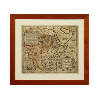
Abraham Ortelius - Map of the Abyssinian Empire

Features

Map of the Abyssinian Empire

Artist:  Abraham Ortelius (1527-1598)

Artwork title:  Mappa dell'Impero Abissino

Age:  16th Century / 1501 - 1600

Description : Mappa dell'Impero Abissino

Hand watercolored etching. It is taken from the Latin edition of the Theatrum Orbis Terrarum, the first modern atlas, including maps of all areas of the world; with a brilliant intuition, Ortelius brought together in a single corpus the heterogeneous cartographic production of the period, forming the basis for an enormously successful publishing enterprise, published several times starting from 1570. The map shows the wording of the territory at the bottom right. represented, with the name of the explorer of reference (in this case a missionary priest in the land of Africa). The print is in good condition, the central fold of the book is visible. Presented in the frame.

Product Condition:
Product in good condition, with small signs of wear.

Frame Size (cm):
Height: 55,5
Width: 62
Depth: 1,5

Artwork dimensions (cm):
Height: 39
Width: 45

Additional Information

Artist: Abraham Ortelius (1527-1598)

Abraham Ortelius was born in Antwerp on April 14, 1527 into a family originally from Augsburg. Orphaned of his father at the age of ten, after a few years of humanistic and particularly historical studies, he found work in a cartographic laboratory, where he was initiated into geographical studies. From about 1550 he made frequent trips, also to Italy where he established friendships and correspondence, and especially to Paris and Frankfurt, whose fair was important both for research and for the sale of papers, and where in 1554 he met the famous Gerardo Mercatore, following whose example Ortelius began to devote himself to the elaboration of geographical maps. Since 1558 he had entered into a relationship with Christophe Plantin, the famous publisher of Antwerp, with whom he became a close friend.n

Age: 16th Century / 1501 - 1600

16th Century / 1501 - 1600
It could also interest you