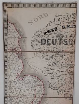
Carta geografica postale del Regno Lombardo-Veneto


By: Giacomo Pinchetti, Giovanni Brenna, Giuseppe Pezze
Code: LISCAS0279814

from 31.67 €/month for 15 months without interest Find out more


Features
Author: Giacomo Pinchetti, Giovanni Brenna, Giuseppe Pezze
Publisher: Gio. Cogliati
Place of printing: Milan
Year of publication: 1848
Product Condition:
Large copper-engraved map glued to canvas on the front, divided into 40 sections, folded measures 21.5X13 cm. Traces of dust, small brown spots and foxing; a slightly larger spot corresponding to the Gulf of Venice. At the upper ends we find two small fabric rings, probably used to hang the map. The folded map is placed inside a marbled cardboard sleeve with abrasions on the edges. The map and the sleeve in turn are inside a marbled case, open only on the upper side: abrasions on the edges and corners, paper tags applied to the plates with the title and publisher data; foxing on the publisher's tag. Texts in Italian.
Pages: n.s.
Format: In eighth
Dimensions (cm):
Height: 85
Width: 132
Description
Map of the Lombard-Veneto Kingdom, drawn by Giacomo Pinchetti, under the direction of the geographer engineer Giovanni Brenna and engraved by the cartographer abbot Giuseppe Pezze. The map has been reprinted several times, our copy is the corrected and enlarged edition of 1848. At the bottom of the map there are 17 boxes with maps of the same number of cities: Milan and Venice (larger than the others), Como, Pavia, Lodi, Bergamo, Sondrio, Cremona, Brescia, Mantua, Verona, Vicenza, Rovigo, Padua, Belluno, Treviso and Udine.
Product availability
Immediate availability
Ready for delivery within 2 working days from ordering the product.
By: Giacomo Pinchetti, Giovanni Brenna, Giuseppe Pezze
Code: LISCAS0279814
from 31.67 €/month for 15 months without interest Find out more


Information
Offers & PromotionsWithdrawal Form
Terms and Conditions
Privacy Policy
Cookie Policy
Update your Cookie Policy Preferences
Who we are
ContactsOur History
Di Mano in Mano Team
Our shops
Why choose Di Mano in Mano
Eviction Service
Shop Information
Di Mano in Mano Soc. Coop.
Register of Cooperative Companies at No. A114664
Contact us Now
Registered Office:
info@dimanoinmano.it
VAT Number: IT12896370157
Believe in Us
General Conditions of Use and Sale. Online dispute resolution according to Art. 14 (1) Regulation on consumer ODR.
European Commission provides a platform for online dispute resolutions (ODR) which can be accessed under: https://ec.europa.eu/consumers/odr/
We Ship With: